
In the aftermath of the Chernobyl nuclear disaster, Italians voted against the presence of nuclear power plants on Italian soil. As a result of this, Felice Vinci, a nuclear engineer and officer of the Italian national energy company (ENEL), was assigned another job, one that he found significantly less challenging. Vinci had been passionate about the epic poems of Homer – the Iliad and the Odyssey – since high school, so he used some of his new-found free time to re-read them. On one hand, he was struck by the incredible consistency and detail of the geographic descriptions in the two poems; on the other, he was puzzled about certain incongruities compared to the real-life topography of the Mediterranean. He decided to dig a little deeper.
The question that emerged in the course of Vinci’s research was electric: could everything in the two poems have taken place much earlier and much further North—in the Baltic Sea and the Northern Atlantic? Vinci’s astonishing discoveries were first published in his book: Homer in the Baltic in 1995, and have stirred plenty of controversy in the academic world ever since. Many scholars dismissed Vinci’s work as pseudo-archaeology, but two decades after its initial publication, Vinci’s ‘Baltic theory’ is slowly gaining a broader consensus in the academic world. If the theory were true, what might it mean for our understanding of western civilization and the roots of European culture? DUST met with Vinci to discuss the genesis and the profound consequences of his intriguing theory. We also met with photographer Ilaria Di Biagio, who has created a thorough photographic documentation of Vinci’s Baltic setting for the Homeric poems. In this ongoing project, Di Biagio takes us on a journey through Scandinavia and aims to capture the misty and oneiric atmospheres of the relocated Trojan War and the voyage of Ulysses.
MF: Mr. Vinci, your theory is very controversial. You argue that the real setting of the Iliad and Odyssey isn’t the Mediterranean, where it proves to be undermined by many incongruities, but rather in the north of Europe.
FV: Right. I argue that the oral sagas that originated the Iliad and Odyssey came from the Baltic regions, where the Bronze Age flourished in the 2nd millennium BCE and where many Homeric places, such as Troy and Ithaca, can still be identified today. The blond seafarers who founded the Mycenaean civilisation in the Aegean in the 16th century BCE brought these tales from Scandinavia to Greece after the end of the Climatic Optimum. These peoples then rebuilt their original world – where the Trojan War and many other mythological events had taken place – farther south in Mediterranean waters, transferring significant names from North to South. Through many generations, they preserved the memory of the heroic age and the feats performed by their ancestors in their lost Hyperborean homeland, until the oral tradition was put into written form around the 8th century BCE—when alphabetic writing was introduced in Greece. All of this is the subject of my book, whose USA edition is entitled The Baltic Origins of Homer’s Epic Tales (so far my book has been published in USA, Russia, Estonia, Sweden, Denmark, Germany and France. A broad summary is in https://www.athensjournals.gr/mediterranean/2017-3-2-4-Vinci.pdf).
MF: Climatic Optimum? According to climatologists, when did the weather start changing in the North?
FV: After a long warm period, the climate change in that area began in the 3rd millennium BCE, but the final collapse of the climate was probably caused by the explosion of Thera (modern-day Santorini) in about the year 1620 BCE—just at the time of the arrival of the Achaeans in Greece. This event had dramatic consequences worldwide. That’s why the Achaeans moved from Scandinavia to the Mediterranean, where they eventually settled at the beginning of the 16th century BCE and started the Mycenaean civilisation.

MF: What are the implications of your theory as to the way we look at Europe and its culture today?
FV: If the validity of my theory will be confirmed through investigation, new and fascinating horizons will open up regarding the origin and prehistory of the whole European civilization. It would be backdated a thousand years—shedding light on the peoples of the Nordic Early Bronze Age and illuminating their life, culture, religion, and history that has been almost entirely unknown until now. It’s a fundamental discovery that will cause us to reframe the origin of our own civilization. This ‘rediscovery’ of Homer could foster a new cultural approach to the idea of European unity based on our cultural heritage as well as the memory of our common origins, and even contribute to the birth of a new humanism in our Western culture.
MF: People usually think that Europe as an entity was initially born when the southern peoples mixed with the northern ones after the fall of the Roman Empire. This discovery can tell us that the roots of our civilization actually originated from a similar mixing thousands of years before. In a passage of the book, you refer to your discoveries as the Ariadne’s thread bringing us back to the very roots of European culture, shedding light on a common origin that might seem quite distant at first.
FV: This common heritage I’m talking about was transplanted from Northern Europe to the Mediterranean area, and was destined to be the first seed of our Western Civilization. The evolution of Mycenaean culture in the Aegean setting, stimulated by contact with the advanced Mediterranean and Near Eastern peoples, led to the birth and development of Greek culture. Afterwards, the latter spread across the world (also through the Roman Empire) until this grand circle which had begun many years before with the Achaean migration from the north finally closed when the Romans came into contact with the Germans—eventually giving rise to our modern civilization. Even the idea of democracy—that is, the most important value that Europe has given the world, whose germ is found both in Greek Agorá and Viking Thing, i.e., the public meetings held in Athens and Iceland respectively—appears now to derive from a common matrix. We should only think on Karol Modzelewski’s remark in his Barbarian Europe regarding a singular custom reported by Tacitus in chapter 11 of his Germania: “[Tacitus’s] mention to the assembly decisions, taken by a particular way of acclamation consisting in brandishing the spears, is confirmed by the 12th-century codifications of the Norwegian juridical traditions, where this rite appears under the name vapnaták”. Well, it is fascinating to note that the custom of going to the assemblies armed with a spear is also found in the Odyssey: Telemachus “went to the assembly, bronze spear in hand” (Od. II, 10). Thus, a custom concerning public assemblies dating back to the Homeric world was still in use in the Viking Norway of the 12th century after passing through Germany of Tacitus’s age. In a word, from North to South, Europe has a fundamentally unitary cultural and political substratum, going back to the Bronze Age, which the Homeric poems left us. Here is Ariadne’s thread which takes us back to the most ancient roots of our civilization—allowing us to find our origins again. Its symbol might be the volutes of the Ionic capitals. Let us think of Athens Erechtheum. Those spirals are a very common decoration of the Nordic Bronze Age. In short, Homer and the Greek civilization can give us a new outlook on old Europe—as well as the modern one.

MF: Let’s go into this in more detail. Greeks coming from the North? Is there any archaeological discovery that corroborates your thesis?
FV: There is a lot of evidence that the Mycenaean civilization had come from the North. In particular, the distinguished Swedish scholar, Prof. Martin P. Nilsson, reports considerable archaeological evidence, uncovered in the Mycenaean sites in Greece, corroborating their Nordic origin. Some examples are: the existence of a large quantity of Baltic amber in the most ancient Mycenaean graves in Greece, which is not to be ascribed to trade because the amber is very scarce in coeval Minoan tombs in Crete as well as in later graves on the continent; the typically Northern features of their architecture, as for example the Mycenaean Megaron which is identical to the hall of the ancient Scandinavian kings; the striking similarity of two stone slabs found in a tomb in Dendra, with the menhirs known from the Bronze Age of Central Europe; the Northern-type skulls found in the Necropolis of Kalkani; and so on. Here is what the famous philosopher Bertrand Russell writes on the Mycenaeans in the 1st chapter of his famous History of Western Philosophy: “There are traces which most probably confirm that they were Greek-speaking conquerors and that at least the aristocracy was made up of blond Nordic invaders who brought the Greek language with them”. As if to underscore this, the famous archaeologist Geoffrey Bibby underlines the common origin of the Achaean princes of Greece and Asia Minor in the 15th century BCE and the sun-worshipping farmers of Scandinavia.
MF: Since ancient times, Homeric geography has been giving rise to innumerable problems of interpretation. Can you share a few examples of this?
FV: The geographic incongruities in the poems, if they are set in the Mediterranean, are countless! First of all, the Homeric archipelago of Ithaca does not fit the Ionian Islands at all. Telemachus’ voyage from Ithaca to Pylos is too short. His swift journey by chariot from Pylos to Lacedaemon along ‘a wheat-producing plain’ is too easy. Agamemnon’s course from Troy to Mycenae, rounding Cape Maleas, is geographically absurd. The very long days in the land of the Laestrygonians are freakish. The allies of the Trojans, such the Lycians and the Cilicians, whom Hector considers his ‘neighbours’, instead lived in Southern Anatolia—far away from the Dardanelles. Moreover, a lot of cultural details that seem strange in connection with the Greek world become understandable in relation to a Northern European setting. For instance, the significance of oxen compared to other animals, or the tableware made solely of metal or wood, which are abundant in the north. Or the ‘backwardness’ of the Homeric civilization compared to that of the Mycenaeans. Or the inconsistencies between the morphology of some Homeric cities and their Greek namesakes. Not to mention the ancient questions of the position of Pylos and Pharos. According to the Odyssey, Pharos lies one day’s sail from Egypt’s coast, but we all know that it is right in front. And what should we think of the Homeric Peloponnese, that is consistently described as a plain in both poems, but we all know it’s mountainous? Moreover, what about the way Homer’s heroes used battle chariots? They got off the chariots and left them aside during the duels. However, according to Julius Caesar, the ancient Britons fought this way. All of this, that scholars consider odd or absurd in the Mediterranean setting, fits the Nordic one perfectly.

MF: By analyzing climate and weather descriptions in Homer, you quickly realized that these too seem to point to a Northern European environment rather than a Mediterranean one…
FV: Actually Homer’s world clearly presents northern features. In both poems, the climate is typically cold and unsettled—very different from what we expect in the traditional Mediterranean setting. The Iliad dwells upon violent storms, torrential rain and disastrous floods, and often mentions snow, cold, ice, wind and fog in Troy, Ithaca and the Cyclopes’ land. As regards the sun, the Iliad hardly ever refers to its heat or rays. The Odyssey never mentions the sun’s warmth in Ithaca—though it refers to the sailing season. Furthermore, Homer mentions various phenomena which are typical of high latitudes.
MF: You are not the first one to suggest an Atlantic setting for the Odyssey. It was suggested by Strabo, the author of Geography, in the 1st century BCE.
FV: True. In relation to Ulysses’ wanderings, he writes: “It is evident that all these things are clearly imagined in the Atlantic Ocean”. This fits what Plutarch says about Ogygia.
MF: Let’s talk for a moment about the famous sentence that gave origin to the whole investigation. What exactly does Plutarch say about Ogygia – the island where Ulysses spent seven years of golden captivity in the company of the nymph Calypso?
FV: In that passage, Plutarch, a Greek author of the 1st century CE, states that Calypso’s island lies in the North Atlantic, “five days’ sail from Britain, towards the sunset” (“De facie quae in orbe lunae apparet”; 941a). If you look at the map, Ogygia can be identified as one of the Faroe Islands, Nolsoy—where, according to the Odyssey, there are caves, meadows, large colonies of seabirds, small watercourses and low beaches that allow a smooth landing. One can even find a mountain there called Høgoyggj!
MF: After locating Ogygia, the other geographic references contained in the poems guided you in the identification process of other cities and regions mentioned by Homer.
FV: Ulysses sails from Ogygia on a raft until, after many days, he reaches the shores of the land of Phaeacians, Scheria, where he is rescued by Nausicaa, King Alcinous’ daughter.

MF: Where do you locate this land? Isn’t it the island of Corfu?
FV: The traditional identification of Scheria with Corfu, an Ionian island not far from Ithaca, is not convincing at all. If its inhabitants lived close to Ithaca, why had they never heard of Ulysses who was the king of Ithaca and the nearby islands? They describe themselves as very isolated: “Remote, we are at the edge of the world and come in contact with no other people” (Od. VI, 204-205). Which is not exactly the case of the inhabitants of Corfu. Given the above, you should consider that after leaving Ogygia Ulysses sailed eighteen days heading east until “the shadowy mountains of the Phaeacian land appeared, which grew very close to him, and looked like a shield on the misty sea”. Those ‘shadowy mountains’ refer to the high Norwegian coasts—likely the fjord area near Bergen. This is why Homer always refers to the Phaeacia as a ‘land’ rather than an ‘island’.
MF: After Ulysses spots the steep coast, a sudden storm blows up. Then the North Wind drives his raft southward for two days until he succeeds in landing at the mouth of the river of Scheria. Have you located this river too?
FV: Yes. It is the modern-day river Figgjo near Klepp on the southern coast of Norway, where there are many Bronze Age remains—i.e., graves and rock carvings that often portray ships. Homer calls the Phaeacians ‘renowned navigators’, although they are unknown in the Mediterranean world. You should also consider that in the ancient Nordic language skerja means rock—which squares with the features of that sea as “only sheer cliffs, rocks and reefs”. It is also noteworthy that Ulysses in his landing took advantage of the reversal of the stream: “By swimming he reached the mouth of a fine river which seemed to him to be the best place as it was free of rocks […] It stopped its current at once, halted its flow, became still, and drew him to safety into the mouth of the river” (Od. V, 441-443, 451-453). This is easily explainable with the Atlantic high tide—a phenomenon typical of the Atlantic Ocean, but not of the Mediterranean. Moreover, at Hamresanden (in Southern Norway, not very far from the Klepp area) in 2010, archaeologists found an unspoiled dwelling site from 3500 BCE, called ‘the mini-Pompeii’ by the Norwegian press, that looks like it was covered by a sandstorm in a few hours. This explains why the Phaeacians were terrified that the god Poseidon would cover their city with a mountain! Incidentally, this idea of the Phaeacian town that might be covered with a mountain is obsessively repeated no less than five times in the Odyssey. This kind of insistence is very unusual in Homer and shows how a danger considered as a sort of a fairytale up until now becomes exceptionally concrete after realising the real Nordic setting of Homer’s tales.

MF: Then a Phaeacian ship escorted Ulysses from Scheria to his homeland, Ithaca. You said earlier that the Mediterranean island traditionally carrying this name in the Ionian Sea does not match the geographic descriptions of the Homeric Ithaca at all.
FV: The location of Ithaca is very precisely shown in the Odyssey. It is the westernmost of an archipelago that includes three major islands—Dulichium, Same and Zacynthus. Instead, the Greek Ithaca is not the westernmost in the Ionian Islands at all, and Dulichium—the ‘long’ (dolichos) island in front of Elis, mentioned in both Homeric poems—was never identified. According to the Encyclopedia Britannica, no amount of ingenuity can reconcile the descriptions given in the Odyssey with the present topography of this island. Above all, the passage in which the position of Ithaca is described offers great difficulties. Moreover, as Moses Finley claims in The World of Odysseus, even the topographical detail of Ulysses’ home island of Ithaca can be shown to be in a jumble, with several essential points appropriate to the neighbouring island of Leucas, but quite impossible for Ithaca. Not to mention that Homer’s Ithaca is ‘low’ (chthamalē), while the Ionian Ithaca is very mountainous.
MF: Is there an island somewhere in the Baltic which tallies with Homer’s descriptions?
FV: The sole group of islands in the whole world which answers all indications of both the Odyssey and the Iliad is the Danish archipelago of South Fyn in Southern Baltic—not very far from the Scheria found in Southern Norway. The South Fyn archipelago consists of three main islands: Langeland, Ærø and Tåsinge. That is Dulichium, Same and Zacynthus respectively. The westernmost island, Lyø, is Homer’s Ithaca. Lyø fits Ithaca perfectly. Not only for its position with respect to the adjacent islands, but also for its topography and morphology. Moreover, between Lyø-Ithaca and Ærø-Same lies a small island—the Homeric Asteris, which, according to the Odyssey, is “in the strait between Ithaca and Same”. It is today’s Avernakø. It is amazing that, according to the Odyssey, 24 of Penelope’s suitors came from Same, 20 from Zacynthus, and 52 from Dulichium (Od. XVI, 247-250). The proportion between the numbers of suitors (24, 20, 52) and the areas of the three respective islands of origin, Ærø, Tåsinge and Langeland (88, 70, 185 sq. km) is astonishing!
MF: This sounds like a perfect match, but allow me to play the Devil’s advocate; I remember that Homer also mentions Ithaca’s vineyards, and I have a hard time imagining wine being produced on a Danish island.
FV: Climatologists generally agree that four and a half millennia ago the climate of our planet—particularly in Scandinavia—was warmer than now (the so-called Post-Glacial Climatic Optimum). The mild climate, comparable to that of the present-day Southern France, permitted a relatively dense population and good farming, with grapes even being grown in Scandinavia at this time. One should also note that in Homer we find two terms, oinos and methy, both translated as ‘wine’. However, methy is easily related to mead (mjödhr in ancient Nordic, meodo in the Old-English epic poem Beowulf), an alcoholic drink produced from honey and diluted with water that was widespread amongst the ancient Nordic peoples and in their mythology.

MF: Are there similarities between the Achaeans and the Vikings?
FV: There are remarkable parallels between the Achaeans and the Vikings in their social relations, interests, lifestyles and so on. For instance, there are amazing analogies between the features of Viking and Achaean ships—a flat keel, a double prow and removable mast. As regards food, it’s remarkable that fruit, vegetables, olive oil, olives and figs never appear on the tables of Homer’s heroes. Their diet was based on meat (beef, pork, goat and game), much like that of the Vikings. Moreover, Homer’s characters had a hearty meal in the morning, like Tacitus’s Germans. Incidentally, the abundance of oxen and pigs in Homer’s world is a further clue of a Nordic setting. One should also note that, while pottery tableware was prevalent in Greece, the Nordic world was marked by a stable and highly advanced bronze founding industry. Homer’s poems only mention crockery and vessels made of metal.
MF: What can you say about Ulysses’ wanderings?
FV: After noting that Ulysses’ wanderings are comparable to the immram of Celtic legends, a map by Adam of Bremen (11th century AC) shows a “Cyclopes’ island” in Norway. We can link them to the Trolls of the Norwegian folklore, who sometimes have one eye and are able to move huge stones. The Island of Aeolia probably is one of the Shetlands off the coast of Norway. Their cliffs fit the description of Aeolia (possibly modern-day’s Yell), whose “cliff rises bare” (Od. X, 4). This is a home suitable for Aeolus, the Lord of winds’ who gives Ulysses the bag containing all winds. Extremely violent storms occur here, with winds exceeding 200 km per hour. It is amazing what James Frazer says in The Golden Bough: “The Shetlands’ seamen even today buy winds in the shape of handkerchiefs and strings knotted by old women who claim to be able to control storms. People say that in Lerwick there are old witches who live by selling winds”. Homer gives Aeolus the patronymic Hippotades, meaning “the son of the knight”. This seems quite an odd name for the king of an isolated island in the middle of the Atlantic Ocean. Nevertheless, it provides us with another remarkable clue, since it becomes natural to connect it with the famous breed of Shetland ponies. Afterwards, Ulysses reaches the land of the Laestrygonians, where there are very long days. If we place it at a very high latitude, this makes total sense—as the Greek scholar Crates of Mallus had already realized in the 2nd century BCE! Here stands “Lamos’s stronghold” (Od. X, 81), whose name recalls the island Lamøy, facing the Norwegian coast. The Sirens are creatures found in Norse mythology, where they are called margýgr. And Circe’s island, Aeaea, lay north of the Lofoten and maybe can be identified as modern-day Håja. The Odyssey mentions here some typical Arctic phenomena such as the midnight sun and the ‘dancing of the dawn’.

MF: So, in the Homeric world we can find some phenomena typical of high latitudes.
FV: Besides the episode of the Laestrygonians, we can find the clear nights of the summer solstice also in the longest battle of the Iliad. We also find evidence of the aurora borealis, when the Iliad mentions Zeus’s “swaying halo” (Il. XVII, 547), and the darkness of the Winter solstice in the Land of Cimmerians. The midnight sun is identifiable at Circe’s island and in Thrinacia, where the Hyperion Sun indicates the sun going over the horizon (hyper-iōn in Greek). The Dawn’s ‘dances’ at Circe’s island are a metaphor for a typical phenomenon of very high latitudes beyond the Arctic Circle, where a ‘revolving dawn’ appears toward the end of the long Arctic night, heralding the reappearance of the sun. As regards Circe, she is described as “the one with many drugs” (polypharmakos). She was, therefore, a typical Lappish shaman, experienced in psychotropic potions. Moreover, Homer calls Circe and her brother Aeetes “children of the Sun”, precisely as the Laplanders call themselves today. Still on Circe and Aeetes, in the traditional Mediterranean setting they lived very far from each other—contrary to what Homer states—the former being located near the Tyrrhenian Sea and the latter in the Black Sea region. By placing them in the Nordic world, this inconsistency is solved at once.
MF: Even some Homeric references to the migration of birds seem to recall a Northern more than a Mediterranean landscape.
FV: There is a Nordic touch in a passage of the Iliad describing the behaviour of the cranes: “The Trojans advanced with clamour and shouting, like birds, like cranes whose clamour arrives at the sky when they fly from the winter and the endless rains” (Il. III, 2-4). Actually, cranes ‘fly from’ the Baltic and other Northern latitudes towards the Mediterranean at the onset of winter. This scene is clear evidence of a typical Northern, not Aegean setting—a Mediterranean poet would have said that the cranes fly ‘from the summer’ instead of ‘from the winter’, since their migration to the North occurs at springtime.
MF: You saw before that Nolsoy in the Faroe Islands perfectly fits the position and description of Ogygia in concordance with what both Homer and Plutarch claim. However, if Ithaca was in Denmark and Circe’s island was in Northern Norway, where was Troy? Didn’t the walled citadel stand before the Dardanelles, where Heinrich Schliemann found it in the 19th century?
FV: The Iliad locates Troy along the Hellespont, which is systematically described as a ‘wide’ or even ‘boundless’ sea. We can therefore easily exclude that this indicated the Strait of the Dardanelles. Also, considering that Dieter Hertel—who worked in the site of Hisarlik and now teaches Classical Archaeology at the University of Cologne—claims in his book Troia that the city found by Schliemann has nothing to do with the Homeric Troy, it makes sense to search for Homer’s ‘wide Hellespont’, and Troy itself, somewhere else.
MF: Now I think we are all very curious about this next part; if not in Anatolia, where should we imagine the city of Troy?
FV: The medieval Danish historian Saxo Grammaticus says that a region called ‘Hellespont’ lay in the Baltic area, where a population living there, the Hellespontians, were enemies of the Danish and were often engaged in conflicts with them. Their stronghold, Duna, is today’s Dünaburg, which lies in the eastern Baltic. By considering that the wide geographical counterpart of the very narrow Aegean Hellespont is the Gulf of Finland (both of them lying north-east of the respective basins), and that Troy lay north of the ‘wide Hellespont’ (as one can infer from a statement of the goddess Hera [Il. XXI, 334-335]) that is, north of the Gulf of Finland, we can assume that Troy was in the area of Southern Finland.
MF: So the Homeric Troy should be imagined facing the Gulf of Finland?
FV: Exactly. After several surveys carried out in Southern Finland, I found the location of the Iliad in an area which tallies perfectly, from both a geographical and topographical point of view, with the city described by Homer. In that area, west of Helsinki, we can find a number of place-names which astonishingly resemble those mentioned in the Iliad and, in particular, those given to the allies of the Trojans—Askainen (Ascanius), Reso (Rhesus), Karjaa (Caria), Nästi (Nastes, the chief of the Carians), Lyökki (Lycia), Tenala (Tenedos), Kiila (Cilla), Kiikoinen (Ciconians) and so on. What is more, the place-names Tanttala and Sipilä (the mythical King Tantalus, famous for his torment, was buried on Mount Sipylus) indicate that this matter is not only limited to the Homeric poems, but also seems to extend to the whole world of Greek mythology. Right in the middle of this area, between Helsinki and Turku, we discover that King Priam’s city has survived the Achaean sack and fire. Its characteristics correspond precisely to those Homer handed down to us: the hilly area dominating the valley with its two rivers, which fit perfectly the reciprocal positions of the Scamander and the Simois, the plain which slopes down towards the coast, and the highlands in the background. It has even maintained its own name almost unchanged throughout all this time. Today, Toija is a peaceful Finnish village, unaware of its glorious and tragic past. Various trips to these places from July 11, 1992 onwards have confirmed the extraordinary correspondence between the Iliad’s descriptions and the area surrounding Toija. What is more, in the neighbourhood we come across many important traces of the Bronze Age—such as the tumuli of Perniö, very similar to those described by Homer. It is astonishing that towards the sea we find a place called Aijala, which recalls the ‘beach’ (aigialos), where, according to Homer, the Achaeans beached their ships. Near Toija there is also the old copper mine of Orijärvi that could explain the wealth of King Priam. In short, both the geographic position of the Finnish Toija and its morphological features fit with Homer’s directions like a glove. Likewise, also by considering the astonishing coherence of Homer’s geography when it is inserted into the Nordic context, all of this entitles us to believe that the Iliad is the faithful chronicle of real historical events dating back to the Nordic Bronze Age.
MF: You mentioned earlier the most prolonged battle of the Iliad—an unbroken battle lasting two days and one night. It plays a central role in your own work, acting as one of the most persuasive pieces of evidence of a Northern setting for the Trojan War. Why?
FV: The fact that the night darkness does not stop the battle is incomprehensible in the Mediterranean world, but makes a good deal of sense in a Northern setting. What allows Patroclus’s fresh troops to carry on fighting through the night without a break is the dim, residual twilight that is typical at high latitudes around the summer solstice. This interpretation allows us to reconstruct the various stages of the battle in a coherent manner, whereas they become a hodgepodge if the battle is compressed in a single day—as scholars usually do because of the Mediterranean prejudice. It is also noteworthy that the day after the end of the battle there is the overflowing of the two rivers of Troy. This tallies with the fact that the spring floods of the Northern rivers usually occur in June, owing to the thaw. It coincides, therefore, with the clear nights.
MF: Is there some Homeric word that indicates the ‘clear night’?
FV: A passage of the Iliad mentions the word used to indicate this phenomenon, which is typical of the regions located near the Arctic Circle: amphilykē nyx ( “around-clear night”). It is a sort of a ‘linguistic fossil’ which, thanks to the Homeric epos, has survived the migration of the Achaeans to southern Europe. One should consider that the Homeric term amphilykē is very uncommon in Greek literature since it refers to a phenomenon unknown in Greece. However, it is found in the Argonautica by Apollonius Rhodius, in a passage where the Hyperborean Apollo is mentioned (Arg. II, 671).
MF: Ilaria Di Biagio, the photographer who is dedicating an ongoing photographic project to your theory and whom we are also interviewing for this piece, declared that one of the most convincing parts of your book is the chapter where you analyze the ‘Catalogue of Ships’.
FV: In Book 2 of the Iliad there are 266 lines of verse known collectively as the Catalogue of Ships that present the list of the twenty-nine Achaean fleets that took part in the Trojan War, together with the names of their captains and places of origin. The sequence is not hierarchical (for example, the commander-in-chief Agamemnon is listed ninth). Instead, it is organized geographically. When this ‘verbal map’ is grafted onto the Baltic coastline, Homer’s descriptions of places and peoples fit perfectly, whereas superimposing it on the Mediterranean area results in a number of puzzling inconsistencies. Starting from what is now central Sweden and moving in a counterclockwise direction around the coast of the Baltic Sea to finish in Finland, the Catalogue of Ships paints an amazingly accurate picture of Homer’s world. By adding other geographical news found in the two poems and in the rest of Greek mythology, one can reconstruct the whole lost homeland of the Achaeans around the Baltic—as well as the world of the Nordic Early Bronze Age!
MF: It is noteworthy that the two poems refer to territories quite far afield.
FV: True. The Odyssey indicates the positions of Scheria, Ithaca and the kingdoms of Peloponnese and through the Ulysses’ wanderings gives us a consistent picture of the Atlantic coast of Norway and the facing islands, up to the Faroe. In turn, the Iliad indicates (in the Catalogue of Ships) the Achaean settlements along the Baltic in the Early Bronze Age, and (in the rest of the poem) the Trojan area with the adjacent regions and islands.
MF: In summary, the geographic information extracted from the entire Homeric universe finds its natural location in some main ‘clusters’: the island Ogygia and Scheria in the Atlantic Ocean; the world of Ulysses in the Danish islands; the world of Troy in southern Finland; the whole world of the Achaeans along the Baltic coasts; and Ulysses’ adventures along the Norwegian coasts and islands.
FV: Exactly. Each of these points closely squares in geography, morphology, climate and place-names to the settings found in Northern Europe, which makes the inconsistencies of the traditional Mediterranean locations even more glaring. Moreover, the Northern setting allows the identification of many of Homeric places that were deemed to be unreal heretofore.
MF: If proven to be true, your theory would question the Eastern Origin of the European civilization. However, some detractors of your thesis claim that it is not confirmed by convincing enough archaeological proof, as suggested by excavations of Baltic coastlines that were populated by Neolithic cultures using ceramic crockery and non-bronze metal objects at the time you suggest. They say that the Scandinavian Bronze Age, in fact, began later.
FV: The method used by scholars to date the findings of the Northern Bronze Age virtually is still the same that was introduced in the 19th century by the Swedish archaeologist Oscar Montelius (1843-1921). However, in the meantime, there have been many important innovations. I’m referring to the radiocarbon dating, corrected with dendrochronology, that had huge consequences for the traditional chronology. Let’s read what Prof. Colin Renfrew, Dean of Archaeology at the University of Cambridge, claims in his book, Before Civilization: the radiocarbon revolution and prehistoric Europe: “These changes bring with them a whole series of alarming reversals in chronological relationships. The megalithic tombs of western Europe suddenly become older than the Pyramids or the round tombs of Crete—their supposed predecessors. The early metal-using cultures of the Balkans antedate Troy and the early Bronze Age Aegean, from which they were supposedly derived. And in Britain the final structure of Stonehenge, once thought to be inspired by Mycenaean architectural expertise, was complete well before the Mycenaean civilisation began”. Moreover, in the chapter significantly entitled “The Collapse of the Traditional Framework”, he goes so far as to say that “the whole carefully constructed edifice comes crashing down, and the story-line of the standard textbooks must be discarded”. Still on Nordic archaeology, Swedish archaeologists recently found a big, skilfully planned and organized city, in the site of Bjästamon, in north Sweden. This city, which extended on more than 1 sq km and dates back to 2800 millennium BC, exchanged goods with the territories of Russia, Karelia, Poland, Germany and Denmark. Moreover, German archaeologists found that two big armies, with thousands of warriors, clashed at the Tollense river, 120 km north of Berlin, in the 13th century BC. Now researchers have begun to understand the battle and its startling implications for Bronze Age society: Tollense’s scale suggests more organization than once thought and professional fighters; maybe warriors from across Europe joined the bloody fray.
MF: What are the major objections to your theory?
FV: I have never heard any serious objections to my theory. If anything, more or less embarrassed silences, especially after the congress held by the University of Rome on this matter and the publication of the proceedings by the Rivista di Cultura Classica e Medioevale. The conservatism of some scholars is often awakened. Prof. Claudio Cerreti of the University of Rome, in his review of Homer in the Baltic , claims: “The Mediterranean setting of the Homeric poems is not a scientific verity, but simply a tradition, which always resulted in endless demonstration problems. But this tradition is deep-rooted and almost ingrained in our culture, to such an extent that it represents the only formidable resistance against any divergent hypothesis”.
MF: Can your theory also explain why Dionysus was almost entirely neglected by Homer?
FV: If the Homeric world followed the Mycenaean age, as scholars still believe, the almost total absence of Dionysus in the two poems would be incomprehensible, because he is a very important god in the Greek world—both in the Mycenaean civilization and in Classical Greece. By admitting that the Homeric age preceded the Mycenaean age, everything becomes clear. After the Achaeans settled in Greece, the features of their gods began to change because of the growing influence of the great Near-Eastern civilizations. But there’s more. My theory can easily explain the significant differences between the respective pantheons of Homer and Hesiod, which are inexplicable if these two poets are almost contemporaries, as scholars usually claim. In fact, the Homeric poems arose from a very ancient oral tradition, dating back to the 2nd millennium BCE, while Hesiod is a Greek poet who lived about the 8th-7th century BCE.
MF: Your book ends with an invitation to archaeologists to go and prove in the field that what you claim is true. If you could decide how and where to dig, where would you start and what would you hope to find? In Toija, for example, I suppose it would be unrealistic to expect massive stone walls like those found by Schliemann in Hisarlik, right?
FV: Right. The Trojan walls, as they are described by Homer, appear as a sort of rustic fence made of wood and stone, similar to the archaic northern wooden enclosures such as the Kremlin Walls up to about the 15th century, much more than the mighty strongholds of the Aegean civilizations. Consequently, the walls found in the site of Hisarlik prove that it has nothing to do with the Homeric Troy! About 1 km east of Toija there is a hilly area that fits with the description and position of Troy, and a place, Kavasto, whose name in Greek sounds roughly like ‘the burnt city’. As a matter of fact, the root of the Greek verb ka(v)io means ‘to burn’ (let us think of the English words ‘caustic’ and ‘cauterize’) and asty means ‘city’. Close to Kavasto there is an oblong hill, about 680 m long, parallel to the river (the Homeric Scamander). It seems to fit very well the features of Troy. The Scaean Gates of Troy (i.e. the ‘Western Gates’, skaios meaning ‘western’) were probably near the western corner, facing the plain and the river. One should also consider that in the same area, east of Toija and north of Kisko, there are some other rises that might correspond to the ancient Troy. However, that hill close to Kavasto seems to be the most promising. Jean-François Maréchal, a French archaeologist, and Claudio Cerreti agree that a core sampling could reveal the ash layer left by the fire that burnt the city.
MF: Your conclusion?
FV: It is time to start specific archaeological investigations in the area of Toija—in particular on the hills around Kavasto and the village of Kisko—and Lyø, which correspond to the Homeric Troy and Ithaca in all geographical, topographical, morphological and climatic respects. These represent promising archaeological sites—as the tumuli of Perniö and the dolmen of Lyø confirm. More generally speaking, we can also assume that the two poems (in particular, the Iliad’s ‘Catalogue of Ships’) helped the Achaeans to keep the memory of the Baltic place-names alive, to the point that the Achaeans-Mycenaeans transposed them in a quite orderly way into the Mediterranean world. Incidentally, that’s why the names of some Greek cities—Athens, Mycenae, Thebes—are in the plural form: their Nordic prototypes extended both on the mainland and on the islands next to the coast, which is a layout typical of the Baltic (the Nordic prototype of Athens, very different from the Greek city, is described by Plato in the dialogue Critias). By returning to the Achaeans now, this way they saved the geographic names of Baltic places and peoples as well as their historical and mythological heritage from the wreckage of the Northern Bronze Age. We must give credit to the Greek civilization for all this. The ancient Greeks preserved and handed down their ancient heritage to us, which, instead of being a fantasy story, revealed itself to be a piece of history of the European prehistory.

*******************************************************************************
The conversation continues with photographer Ilaria Di Biagio.
MF: How and when did you stumble upon Vinci’s theory ?
IDB: It happened by chance. A friend of mine mentioned Felice’s book, Homer in the Baltic, during a dinner in 2016. A week later, I had already devoured it. I started the book convinced that it would probably be a good example of well-written fanta-archaeology, and quickly realized that I was dealing with a very intriguing, coherent theory based on very reasonable arguments. The amount of data Vinci condensed in this volume to support his theory is impressive..
MF: You decided to produce a photographic version of Vinci’s book, and set out on a long tour that took you all over Scandinavia. What did you expect to find, and what did you eventually find in these places?
IDB: I started the journey thrilled at the prospect to physically retrace his theory. At the same time, I was worried about the photographic side. The aim to visually ‘give the feeling’ of a story that happened 4000 years ago gave me the opportunity to start dreaming up and testing new ways of expressing myself through the photographic medium. Moreover, I was honored to have become, in a sense, Felice Vinci’s eyes. As detailed as his book is, he only had the chance to travel to some of the sites mentioned in the book as possible locations of the Homeric topoi. I quickly realized I was playing an important role also in his research. After a while, it was too late to go back. I felt like Ulysses—an explorer of the past, facing the unknown and looking for the next new landing.
MF: What are you trying to capture with your pictures?
IDB: In order to develop the project, I have been traveling extensively through Scandinavia, looking for mythological elements and links with the epic past according to Vinci’s theory. I’m looking for atmospheres, colors and lights that would convey the idea of ‘another world’. What impressed me is that I did not have to force anything to achieve this. The North is immersed in the dark for months, lit only by northern lights and then by days of infinite light, and is today much more tied to nature and ancient traditions than we typically are in the temperate Mediterranean..
MF: What is in your opinion the greatest strength of Vinci’s book?
IDB: Without a doubt the geographical investigation. It’s stunning how well Homer’s geographical descriptions correspond with the locations in the Baltic that Vinci describes.
Having been to these locations, I would say, it is hard not to get the feeling that it could all really have been happening there—where the winds are strong, the sea is a hostile element hit often by storms, coasts are misty, nights (or days in the summer) are never ending and the Peloponnese is, as Homer insistently describes it in the poems, a flat land.
MF: What is the state of the theory.
IDB: The theory is 23-years old and is nearly forgotten. Vinci told me that he was convinced his book would have stirred a lot of controversy and ignited a vivid debate among scholars. That it would have been a sensation. In contrast, his theory has been mainly dismissed as unscientific. Nevertheless, he has never stopped believing in the value of his findings and, over the past ten years, the book has been translated into several languages. Little by little the Baltic countries have started to be interested in the theory. Recently, he has been invited to hold conferences in Estonia, Finland and Greece. The academic world is finally opening its doors. Only slightly, however!
MF: I like to look at Vinci’s work as a reminder of the importance of thinking autonomously, which is also the fil rouge of this issue. We shouldn’t forget that many of the greatest discoveries in human history were borne out of the question: what if this common place or this common reality, which humans have taken for granted for centuries, was simply not true?
IDB: Vinci raises an important notion—that we are allowed to question history. We tend to take the past for granted, as if it was an absolute truth, despite knowing that there is so much yet to be discovered..
As the author of this photographic work, I make no claim to confirm nor to refute the thesis. I started this work simply because I found it intriguing to look closer at how ‘history’ is transformed into ‘authority’. And because I admired Vinci’s capacity to question topics assumed to be indisputable. We should always welcome serious, alternative theories like his that have the courage to cast doubts and to suggest new possibilities. Vinci is actually not even questioning history: he’s telling us that stories we simply believed to be epic, fanciful narratives of the ancients, are instead the mirror of something which really happened, and for which no narration has come—the prosperous Nordic Bronze Age. Homer’s epic tales tell stories which carry tremendous power to this day. They talk about the eternal wandering of mankind, about doubt and perseverance. We can hold these stories up as mirrors. The strength, the emotions, the life of the characters is something we all can deeply identify with, in spite of all the years that have passed. But that doesn’t mean we cannot engage with them and challenge their veracity.
Published in DUST 14, “Every Reaction is a failure”, December 2018
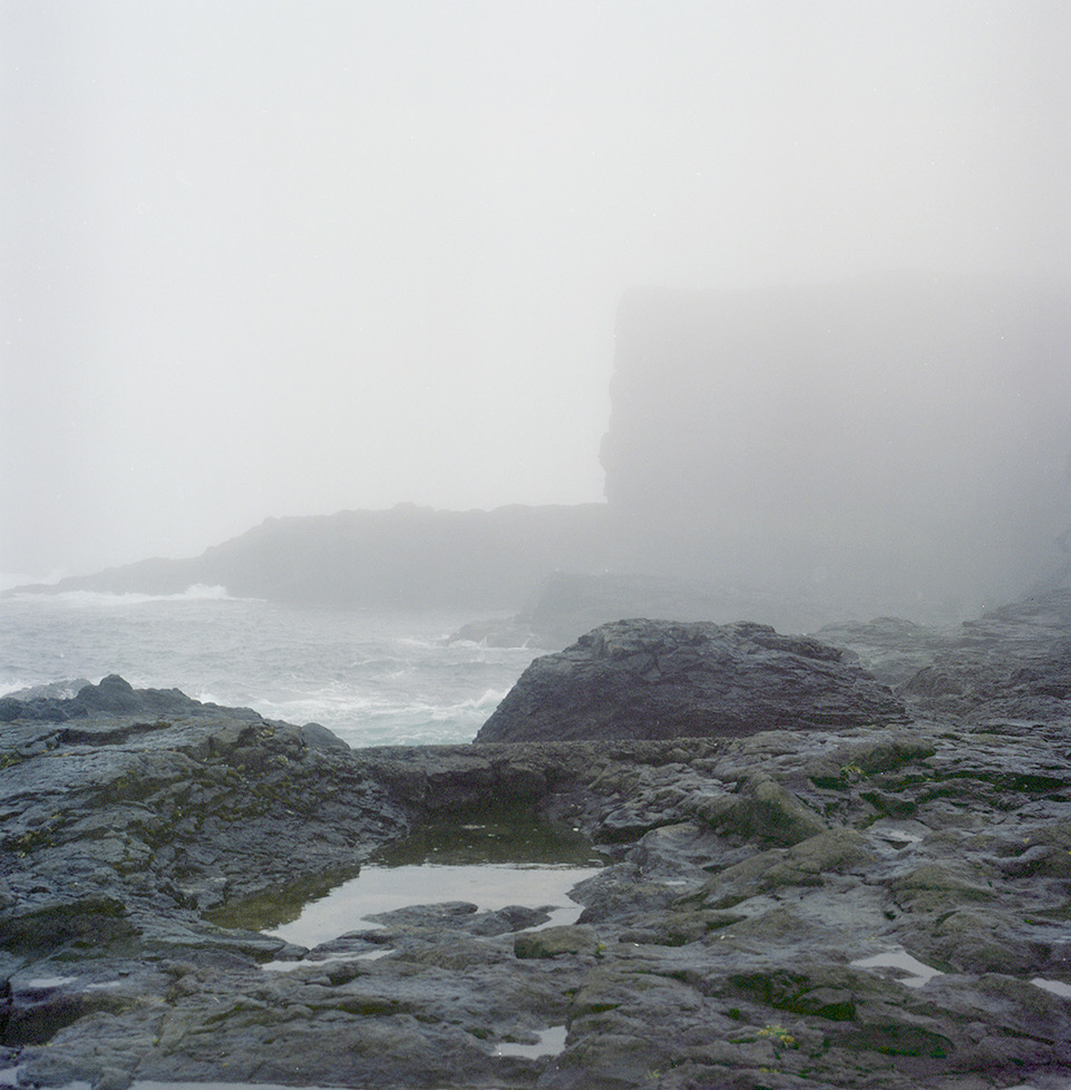
Faroe Islands, DK

The image of Athena, freezed in the landscape. The area is flourishing of Bronze Age ruins: mostly dolmens in strategic locations and menhir spread around the woods.
This one is called Havängsdösen: it is a stone-buried (megalithic) burial mound of the early stone age , dating to about 5 500 years old.
The image is not added with photoshop, the photo is as it is in the shot and RAW file. Photo by Ilaria di Biagio.

The mountainous area of Pyhä, Lapland (in Finnish Pyhä means sacred). This area is indicated by Vinci as the Nordic Olympus. The highest mountain is 500m above mean sea level, and despite its modest elevation it is a favorite spot for winter sports. In fact, Finnish territory, compared to Sweden and Norway, is rather flat with rare peaks. Photo by Ilaria di Biagio.
Faroe Islands, DK. Photo by Ilaria di Biagio.
